

INTRODUCTION:
The Indian state of Meghalaya has three mountain ranges – Garo in the west, Jaintia in the east and Khasi in the centre. While each range has its own unique landscape and indigenous tribes, the most famous of them are the Khasi hills which also house the capital of the state, Shillong. The rural mountainous beauty of Meghalaya lies mostly untouched, largely due to the fact that most parts of the state can only be accessed by road, hence most people stop at the conventional spots and head back home. We felt that the saying ‘The journey matters and not the destination’ is very apt here as we spent so much of our time taking in the scenery on the way to our destinations. Meghalaya means ‘the abode of clouds’ and the state lives up to this name by receiving some of the highest rainfall in the world. The reason why the state receives so much rainfall are the unhindered plains of Bangladesh, moisture-laden winds blowing from the Bay of Bengal sea move through the plains of Bangladesh and through the narrow valleys of Meghalaya till they are forced up the valleys and experience a sudden increase in altitude and form clouds, which leads to condensation and hence precipitation. With the geography lesson done, let us move on to History.
HISTORY:
The dominant tribe of the Khasi range is the Khasi tribe. Etymologically, Khasi means ‘Born of the Mother’; the system of Matrilineality, where family wealth and name is passed on to the youngest daughter, is prevalent in Khasis even today. The youngest daughter gets a lion’s share of the parents’ property and stays with the mother in her house after marriage. Throughout generations since their migration, the Khasis have not had a script, and their history has been in the form of monolith-erections at various sites, which is one of the ways we can learn about their history, most of which is orally passed down. For centuries, they believed in ‘Ka Niam Khasi’, their animist religion which included worship of the forest and other natural surroundings. Things changed with the introduction of Christianity by the missionaries, a majority of the tribal people were converted, but somehow a few still follow their ancient ways of nature worship.
BEST SEASON TO VISIT:
Though it rains most of the time in Meghalaya, there is a ‘rainy season’ that runs from June to September. Though travel during this time is considered risky, we suggest that you travel sometime before the season ends, preferable in August. You will get to see many seasonal waterfalls on the way and some greener grass. The downside is that you may not be able to see other places surrounding Meghalaya as they remain closed during this season, but you can always return.
HOW TO REACH:
We suggest staying at Shillong, Shillong can be reached either by road from Guwahati or by flight from Kolkata. The flight service from Kolkata is 6 days a week (except Friday) and is very convenient being a noon-flight. Most travellers, however, prefer travelling from Guwahati by a taxi or by bus. A bus will set you back by 150 INR and a taxi by 1300 INR. You could also opt for a seat on a shared taxi; which was perfect for us as it cost us 300 INR a person and also included a 10-minute halt at Umiam Lake.

Tip: Taxi drivers who make the trip drive in a very rash manner and it is better that you explain to the driver that you are in no hurry to get to Shillong.
ACCOMMODATION:
No matter the cost, stay at Police Bazaar in Shillong as you can commute easily and also gorge on the local cuisine. There are a lot of options for stay and all of them are over-priced, but stay here anyway, since local commuting is no easy task for an ordinary traveller. Most travellers opt for a ‘Hub and Spoke‘ model of travel with Shillong being the Hub.
When at Mawsynram, the only proper accommodation is the PWD Guesthouse which should be booked in advance. The rest appear to be small homestays, we did not check out any of them as we did not plan to stay there. And at Mawlyngbna, we have the Mawlyngbna Traveller’s Nest. At Mawlynnong, there are many options available, even though they cannot be booked online; most houses in Mawlynnong have options of homestays.
If you are planning to stay at Cherrapunji, then you can opt for Pateng Homestay among other homestays available. We had a great experience there as the family that ran the place certainly knew a lot about the tourist spots in Cherrapunji or Sohra, as they call it. We recommend a homestay rather than a hotel as the locals sure do know how guests should be treated and they also make food that is much better than what we had at any of the restaurants available.
LANGUAGES SPOKEN:
Many people understand English and Hindi; we had absolutely no problem in Shillong, but once we started exploring, we and our local driver too, had problems because the languages and words to represent directions changed from region to region. Your best bet is to find someone who can understand you or your mimes, but the people, in general, are warm to tourists.
FOOD:
Street food in Meghalaya caters to both the vegetarian and non-vegetarian palate. To the vegetarians, it is better to stick to proper restaurants when in smaller towns.
Do remember to check out this little cafe called ML 05; it is close to the Air Force Museum and is a ‘cute little cafe’. The rates are reasonable and the taste makes the food worth the cost.
TRANSPORT:
Transport is costly in this part of the country. Government-run buses ply between major cities or towns, but private taxis or buses are the norm here. Most taxi operators run one-day tours that usually start and end at Shillong. It is somewhat costlier if you booked a taxi for more than one day.
Tip: We did find a taxi-driver who was ready to explore many places with us and charged us a very nominal fee. If you would like his phone number, do drop us a message or comment on this post.
SIGHTS AND PLACES TO SEE:
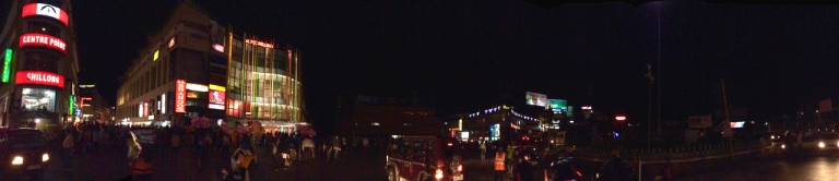
Assuming you do start your tour with Shillong, the first of the places that you must check out is the Don Bosco Museum in the Sacred Heart Theological Society. In fact, before you proceed with your tour of the North East, this museum will help you understand everything that you need to know about the land, the climate, the crops, the people and their traditions. There are seven floors each housing different galleries, with a skywalk on the roof that gives a panoramic view of Shillong city; the advantage of being situated right in the middle of the city.

The entry ticket of 100 INR (200 for foreigners with a concession for students) can be purchased from the counter outside the museum; do note that there is a separate ticket for a camera which costs around 100 INR. Before entering, you may want to check out the Food gallery, though a majority of the dishes are non-vegetarian.
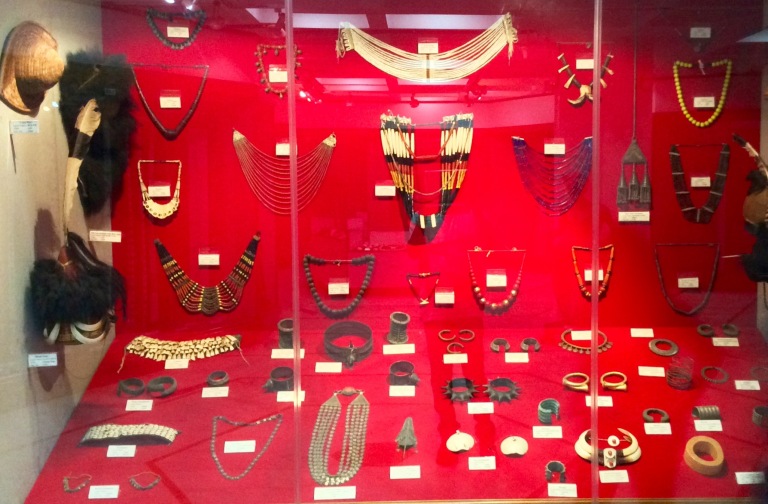
We were welcomed by the Alcoves gallery which is in the ground floor, but we were directed towards the basement floor from where the tour starts. Here is a quick run-down through each floor of the gallery: The basement floors contain the Mission and Cultures gallery, Introductory and Pre-history gallery and the Land and People’s gallery. Here, you may spend more time with the Cultures gallery as it provides an insight into what the other floors hold. The rest of the galleries in the basement can be seen in a matter of minutes, at least that is what we did when we saw across a board saying Creationist and Evolutionary theories are the same. As we proceeded up the stairs, we came across the Fishing gallery and Agriculture gallery on the ground floor. These galleries also contain digitised libraries with details of the tools used by each tribe in Fishing and Agriculture. On the first floor, we have the Traditional Technologies gallery, Basketry gallery and Musical Instruments gallery; the most interesting of these seemed to be the Musical Instruments gallery which seemed to amaze us with its sheer numbers and variety of Instruments. Further up the stairs is the Weapons gallery; we were kind of disappointed with a rather restricted display of weaponry, but the institute seemed pleased that there were not many arms. To make up for the dearth of display in the Weapons section, they have the Costumes and Ornaments gallery, which was coincidentally where we spent most of our time. Further up, the large model of North-East India in the Don Bosco and Culture gallery caught our eye, we could clearly see how the mountains of Meghalaya rise up against the vast flat plains of Assam and Bangladesh. The third floor contains the Housing Pattern gallery and a gallery that could be a real treat to art lovers, the Art gallery. The last of the exhibits is the Media room where one can watch a ten-minute documentary about North-East India. Finishing the tour with an amazing view of the city from the roof is the best part. You can find more in detail about Don Bosco Museum over here.
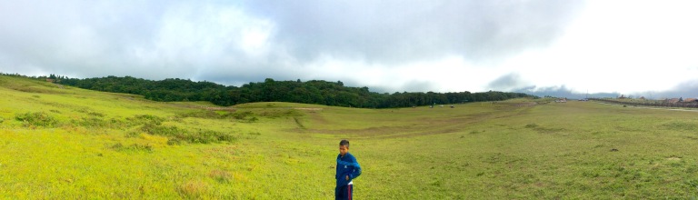
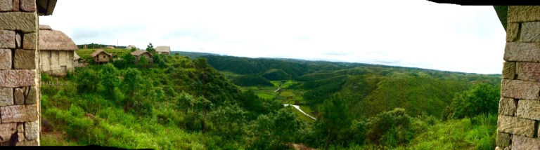
The typical day-tour of Shillong will cover a few rather bland spots such as Ward’s lake, Hydari Park and a Golf Course in addition to a few exciting spots. We have tried to restrict our post to those places only, deemed exciting by us. One of them is Mawphlang, or rather the Sacred Forest at Mawphlang located nearly 30 kilometres from Shillong. The people living in Mawphlang hold their forest in high reverence. Mawphlang and the road leading to it is very scenic with vast plane fields of green grass that are a haven for anyone wanting to laze around or kick a football.
To get into the sacred forest, you need to choose a local guide. They are usually from the community that guards the forest, in fact, this community calls the forest their grove or garden. We too chose our guide and he just so happened to be the son of the village chief, only by title though. He explained to us everything we needed to know about their sacred forest and how it was very important that we follow their rules. The community here considers the forest to be inhabited by a living spirit or protector and this sylvan spirit would protect them when they entered or travelled through it. It was important that we not take anything OUT of the forest. We could consume any of the fruits that we chose to, but they could not be taken outside. Anyone who fails to comply with these rules is cursed by the guardian spirit. It was after explaining these rules and making sure that we understood them that our guide started the tour. Locally, the forest is known as Law Lyngdoh which means that it is ruled by the Lyngdoh or Priest. There were various such other sacred forests throughout Meghalaya many of which were given the title Law Lyngdoh, but incessant and illegal plunder has led to the survival of only a few of which Mawphlang is one.
We were greeted by three stones erected at the entrance; the Khasis have a practice of erecting an odd-number of stones for each event commemorating some joyous event such as election of a new chief or birth of a son, or some event related to death. We find that the rituals undertaken during death bear a small, but important resemblance to those at Rantepao (blog coming soon!!!). There are various such installations across Meghalaya commemorating important events of the tribes.

The forest has a well-defined natural boundary and the locals want to keep it that way so it would not eat into their settlement, which is why anything including seeds cannot be taken out of the forest. As we go deeper, the vegetation thickens to an extent that it even becomes dark during the day. There is a variety of Flora including Rhododendron, Fern, Pipli and Yew and the variety of Fauna include Civet, Flying fox, Flying squirrel, Pangolin, Bulbul and many species of snakes; we even saw a small snake just as we entered. It is home to a number of endangered species of Flora, many of which have medicinal value and hence the forest is vulnerable to illegal activity. The activity of the community in this regard is commendable as this remains a well-preserved forest to date. We recommend you do the hour long-trek that takes you deep into the woods, close to trail of the David Scott trek, which also gives you a feel to what you can expect during this 16 kilometre-trek. The David-Scott trek takes you through the route chosen to travel from Bangladesh to present-day Meghalaya, by the 19th century British officer, David Scott, who discovered this trail following a herd of mules.

Our guide took us to a clearing where rituals are performed by his tribe. There was an area for preparation for the ritual which included the slaughter of a white bull, it is said that once the tribe enters the forest, they must stop here to check if they have all the necessary items so that they can turn back before they reaching the final place where the slaughter is done. But once they reach the final altar, there is no turning back and the bull has to be sacrificed. The meat too, cannot be taken outside; it is cleaned, cooked and consumed inside the forest itself. In the olden days, slaughter was common, but nowadays it is done only when there is the announcement of a new tribal chief.

Legend has it that many generations ago, after emerging victorious in a major battle, the 12 major tribes of the Mawphlang region got together to decide a chief for their territory or Hima. This being a democratic decision, each of the tribes felt it better to get an outside leader and they approached a fearsome warrior from Assam named Khmah Nongsai to let her son be their chief. She proclaimed that if the gods willed so, then her son would become their leader; to see if the gods were willing, she planted three seeds at a place called Phiepandi, which is part of the present-day Mawphlang forest. Her condition was that if in three years, the saplings survived, then they stood testimony to the will of the gods and if not, she would not allow her son to be their chief. It turned out the gods were willing and her son was crowned the chief of Hima Mawphlang with the title Lyngdoh. To this day, the Lyngdoh clan remains the protector of the forest and of the tribes of Hima Mawphlang, it even conducts the Durbar or administrative meeting. The few trees at Phiepandi grew into the forest that we know today as Mawphlang. Our guide here seemed very interested in telling us stories and do make sure you ask your guide too.
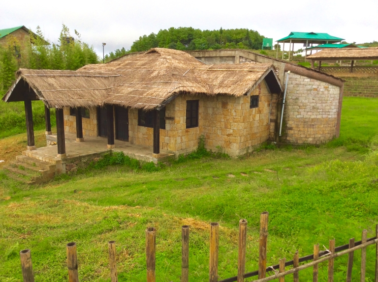
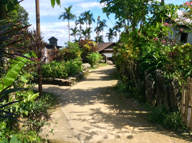
Just as we exit, we saw the Khasi Heritage village just across the road. This place has real-size models of Khasi homes and other structures depicting the traditional day-to-day activities of a Khasi tribe. This is the site of the famous Monolith festival that attracts tribal communities from around the world. The village depicts the houses from various regions such as Myliem, Ri Bhoi, Nongstoin among others. There is also a rope bridge that gives you a feel of a root bridge when walked upon. For those who do not wish to travel further to Sohra or Mawsynram, this bridge can give you a pretty good feel of walking on a root bridge. We will cover more on root bridges in this post when we get to Sohra. Also, do remember to feast your eyes on the gorgeous landscape from the View Point inside.

Two sites much closer to Shillong are Elephant Falls and the Air Force Museum and can be visited in quick succession as they are opposite each other. Elephant falls is hugely popular due to its proximity to Shillong which makes it the quintessential travel destination for those flocking to Shillong in search of nature and fresh air. Elephant falls was the name given to this stepped waterfall because of a rock on one of the steps that resembled an elephant. The rock itself is no more, thanks to an earthquake, but the name lives on. The locals know it as the ‘Ka Kshaid Lai Pateng Khohsiew’ meaning three-stepped waterfall, the three steps are starkly visible if visited during the rainy season. There are two routes that can be taken while visiting this place, one is from the top of the waterfall that attracts more tourists, it also allows access to the water. The other route is to enter through a garden from the front of the waterfall, but does not allow access to the waterfall. This garden is relatively more peaceful and offers great photo ops.

The Shillong Air Force Museum is situated inside an Air Force base which means that photography is allowed only inside the museum. We were welcomed at the entrance by an MI-4 Helicopter, an AWACS system and many aircraft components laid out to display. We supposed that they life-size replicas, but they were actual decommissioned planes. The museum also had an exhibit about the history of fighter aircraft starting from the First World War. The highlight was the display of war-time exploits of the Eastern Air Command of which the base itself is a part. Photographs from campaigns of the Second World War, the India-China conflict and India-Pakistan conflicts decorate the walls of the museum.

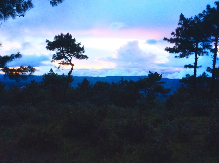
Another popular tourist-spot is Shillong Peak which offers a good vantage view-point of Shillong city and the surrounding canyons. The view-point is set near a military base and on a good day, you could even visit the base inside. We reached there in time for the sunset and opted for the view point outside the base. There were very few tourists around and this was good for us. We had our moment of calm here as we took a deep breath of the cold air blowing at us as we watched the sunset. You can keep this as the last point of your trip as it is quite close to the city and can be reached easily. Do remember to leave quickly after sunset as this place is not the safest of places, at least according to our driver.
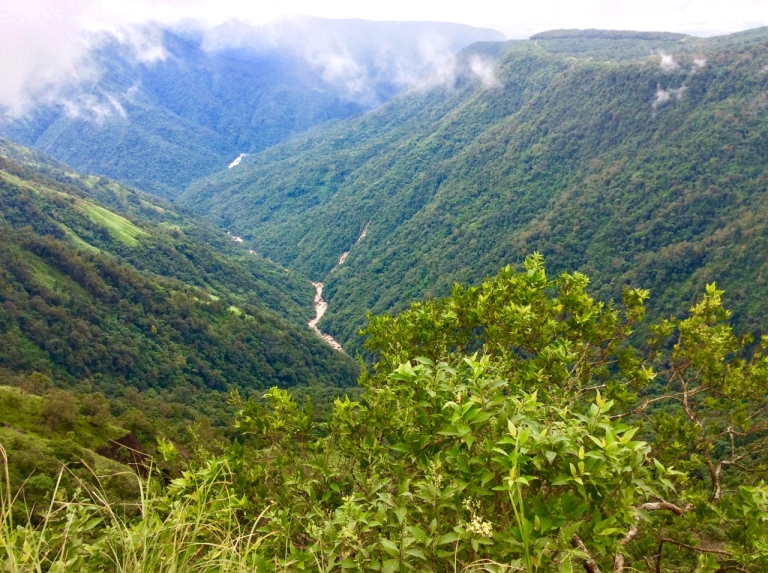
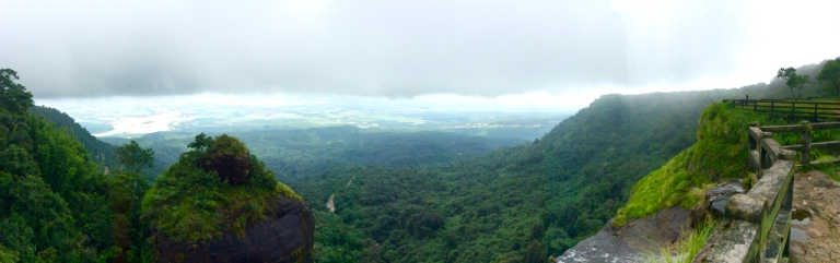
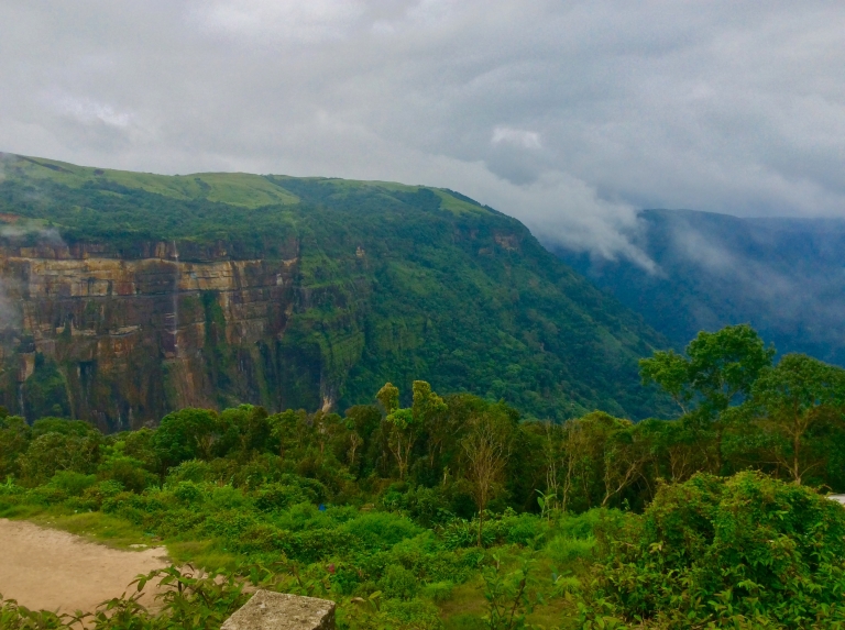
If you were to think that this is the best view in the vicinity, then Laitlum canyons would prove you wrong. These canyons have some of the most breathtaking views of the surrounding valleys, but these views are subject to the vagaries of weather and what is visible and beautiful becomes shrouded in thick clouds in a matter of minutes. Yes, that is right, in a matter of minutes !!!
You may chance upon the bamboo cable cars that are used for transporting food and other small goods from the valleys. Perhaps they also send down the tonnes of cabbages that they farm atop these hills. If you head out to these canyons and end up with no views, fret not, for the village of Smit is nearby. It is a small Khasi village that is famous for the thatched palace commonly known as ‘Ing Sad’. This thatched palace is made entirely of wood and contains not a trace of metal. It sits majestically, overlooking a huge ground where the Nongkrem festival dances take place. A few lucky travellers have even met the king who sometimes visits here, we were not so lucky though. The porch of the palace is made of solid wood and even sports wooden balustrades. There are various inscriptions on the door which we are sure have some significance to them, we wish we had a guide there to help us. Also, the caretakers do not take to strangers very kindly, so snooping around the palace is to be avoided, best to be on your way after clicking a few snaps.

But then, the Khasi hills are not all about Shillong and nearby places, in fact, a few travellers throng Meghalaya to get a feel of the rainiest place on earth – Mawsynram. It was formerly Cherrapunji, but is Mawsynram now. Traditionally, cab drivers take you to just Mawsynram and while you are mesmerised by the natural beauty on the way there, they turn around and drop you back at Shillong before the day ends. Unless you are running out of time, do not go for this.


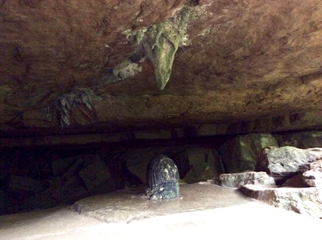
While Mawsynram by itself offers very little to the traveller, it serves as a base for Mawlyngbna and beyond. The most noticeable of destinations is the Mawjymbuin cave that houses a naturally-formed Shiv Ling. This cave draws the religious folk as well as the cave enthusiasts alike. The stalactite-stalagmite formations are starkly visible when visited on a bright day, but as the cave is accessible only by a flight of stairs winding down from the road, it is dark. This darkness and the echo of gushing water make the cave appear exciting. The locals warn people away from exploring the place further as they say there is a river flowing just behind the Shiv Ling, one that is treacherously swift and ends in an underground waterfall. This did not deter us from popping in just to an extent that we felt was safe. Water dripping from the roof and narrow crevices certainly made the experience slushy, but what actually deterred us from exploring was the smell as we went inside the cave. Ironically, the entrance of this cave seems like a good spot for meditation with the sound of water gushing nearby and an air of tranquility.
Few people head over to Lawbah or Mawlyngbna for they do not know about these places, and those who do know are discouraged by their drivers who do not want to drive through the rugged off-road type terrain with no proper roads. Mawsynram, by itself, is secluded and retains a traditional touch and one can only imagine how it would be further inroads.
One such offbeat village is Lawbah , which is famous for lake Umkhakoi. It is far away from Shillong and is not so high up the mountains either; it is from here that one can see the Sylhet plains of Bangladesh. We were not fortunate enough to visit Umkhakoi as the road was closed for repairs and a 10-kilometre walk by foot was simply out of the question here. So, we visited Jakrem hotsprings known as Mih Um Spring Lawbah by the locals. The locals claim that the hot water has many healing properties and is beneficial to the skin. The water spurts out from the ground and forms a small waterfall as it flows down into a stream. The locals can be seen using this stream for their daily needs and also as a spa. While there are separate bathrooms built for bathing, the way to indulge in these hot springs is in the open. We followed the stream to its origin, which we found was just a couple of boulders submerged in a pond that has been cordoned off to prevent contamination.

Tip: Do not visit expecting a huge spring with many facilities for bathing, there is a small stream and a few steps which can seat people.
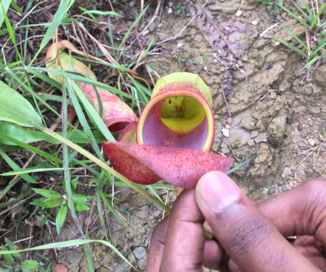
As the road to Umkhakoi was closed, we decided to make best use of the time left with us and visited a cave nearby, Traw cave. We hired a guide from Lawbah village and sans any caving equipment dove into what we thought was a fascinating cave of natural wonders. What it really was, was a cave with a vertical-drop entrance and absolutely no light inside and of course, creatures that did not need light to survive (bats). We joked that there could be snakes in there and our guide casually agreed and asked us to be careful too. We went down five levels to the point where the entrance of the cave was no longer visible and our driver, who was with us, panicked and started forcing us to leave. Our common sense appealed to our adventure sense and we decided to leave. The only picture that we have of the cave is at the entrance. On our way back, we noticed that the sound of insects had increased dramatically to the point that it became noisy. Our guide told us that insects tend to become noisy towards the evening. With so many insects, it was only natural that their predators be around there. And no, predators are not necessarily animals, here we are talking about endangered pitcher plants. Only read about in textbooks, a real-life pitcher plant in the wild drove us wild. And once we started exploring, we found many more, especially once we knew what we were looking for. We were, in fact, disappointed that we were unable to see anything worthwhile and had to head back to Shilong, but the sight of pitcher plants made our day. Do remember to leave early from Shillong if you want to visit Mawlyngbna – it is known for its fossils and Ka Iew Luri Lara (Animal market).
Tip: It is very difficult to spot Traw cave, do keep noting the signboards on the right side of the road a few kilometres before Lawbah. As a pointer, you could note that we passed the Traw cave before passing a wooden bridge leading to Lawbah. Also, do not go ahead exploring Traw cave without a professional guide.
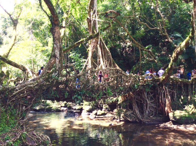
While we did not experience Mawlyngbna, we did experience rain at Mawsynram, rain, however, would be an understatement, as downpour seemed more appropriate. It was actually difficult for our driver to drive in the rain and we had to wait till the rain stopped. Sohra or Cherrapunji, however was not so very blessed by a downpour during our stay. We had stayed at Sohra, after visiting Mawlynnong and Dawki. Mawlynnong shot to fame after being featured on Discover India as the cleanest village in Asia. Even though it is nearly a three-hour, hundred-kilometre drive from Shillong, the roads are in decent condition and can be covered on the way to Dawki. Our visit to this circuit started early in the day from Shillong and by noon, we had reached Riwai; it is famous for root bridges.

Meghalaya, as we know, receives some of the highest rainfall in the world and rain here is part of everyday life. While rain does not hinder day-to-day activities, floods and seasonal streams do and the people here have devised ingenious ways to get past these. One such ingenious and natural solution is the building of root bridges across streams or rivers. Traditional bridges made of bamboo or timber would merely rot and break, and repairing of such bridges was not feasible. So the people had to come up with a better solution and living root bridges were the solution, the secondary roots of the rubber tree that grows in this region would be perfect for the purpose. These secondary roots grow from the trunk, above the soil which makes it easier to bind them and control their direction of growth and since they are living, there is no need to worry about them rotting. Hollowed betel tree trunks are used to shape the direction of the growth of roots. If trees are grown on both sides of a river, then the roots can be entangled to create a bridge. The most amazing part is that as the roots age and become weak, they are reinforced by new roots and the living bridge is as strong as ever. The bridge at Riwai is believed to be a hundred years old and can hold even 50 people at at time.
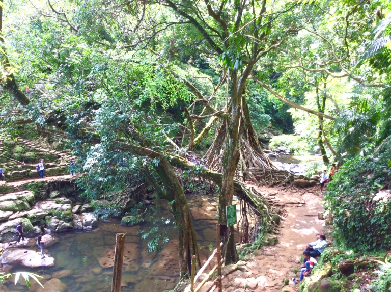
Riwai, on the way to Mawlynnong, is one of the easily-accessible root bridges, it involves just a 30-minute trek to and from the root bridge. The root bridge is part of the River Valley Eco Park that features a park, a play area and cooking facilities for a barbecue-party and the village itself. There is also a Sky Walk which can be reached by crossing the root bridge. The Sky Walk provides a vantage point view of the Sylhet plains of Bangladesh. Unless you plan on a 6-hour trek to the root bridges of Sohra, we suggest you visit Riwai.
We wrapped up our visit to Riwai quickly and proceeded to Mawlynnong. The fame has had a rather mixed effect on this small village of a hundred-and-fifty-households. While the villagers can certainly use the revenue from tourism, the staggering number of tourists has made it a little difficult for them to keep maintaining the same level of cleanliness. Tourists are advised at the entrance of the village regarding its rules and regulations which include maintaining the cleanliness. But, nevertheless, they have their everyday schedule which includes cleaning of their village. Every person, including the children of this village clean their surroundings in the morning before proceeding to their jobs or school. The kids are taught these life lessons at school too, which inculcate the importance of cleanliness in their everyday life.

Further, there are volunteers who sweep the streets at regular intervals during the day. The waste that is collected is discarded into a giant compost pit which is used as fertiliser for the crops. Apart from the bamboo huts that are traditional to the Khasis, there are also bamboo dustbins at every nook and corner that you have to take hardly ten steps to reach a bamboo dustbin. We wandered for a few moments inside this utopian village before we proceeded to enjoy a stunning view of Bangladesh from atop a bamboo tower. There is also a long road leading towards the plains that crosses a small stream. We travelled for some time down the road, but had to turn back as we were running late for Dawki which needed a lot of daylight time.

Technically, Dawki is in the Jaintia hills, but since we do not have a trip planned there in the near future, we will be covering it here. Every travel video of Meghalaya features a green river that is so clean so you could see the bottom; it is the Umngot river at Dawki, a small town at the extreme edge of the India-Bangladesh border. After travelling along the border and crossing over a bridge from the Khasi hills to the Jaintia hills, we reached the border town of Dawki and headed to the river at Jaflong 0 point. Boatmen came running to us asking us if we wanted a ride in the river, we had a short, fun-filled ride. The boatmen explained to us that since it had rained the previous day, the water was not as clear as it generally was. Although we could not see the river-bottom, the water was very clean and at a few places, we could faintly make out the stones at the bottom of the river. The water was so clean that it reflected the green foliage on the Indian side of the border and the blue sky on the Bangldeshi side of the border.

The border post from where people can cross is Tamabil which is a few kilometres from here, but at Dawki too, one can see the border and Bangladeshi people standing on the other side. There are BSF guards on the Indian side of the border who unofficially announce the border as there is no demarcation or fence as such. We were not allowed to take pictures of them and so we we refrained from taking any, although we did technically step into Bangladesh. On the border, there were many Bangladeshi vendors selling tasty snacks and fruits. We gorged like there was no tomorrow and paid them Indian rupees, which they happily accepted. We departed with a full stomach and a full heart and headed to the most important destination of our trip – Sohra.

After reaching our homestay late in the night, we had a heavy dinner and hit the bed quickly. We started our day early and proceeded to the first stop of the day: Nongsawlia Presbyterian Church, the first church of Meghalaya, built nearly a hundred years ago. From just a few members when it started, the church now commands a strength of more than 500,000 members, a strength it has built through conversion of the local tribal folk by Welsh missionaries. The first missionary to arrive at Khasi hills was Thomas Jones, who also setup schools at various locations to spread his teaching. He is credited with giving the Khasi language an alphabet derived from English.


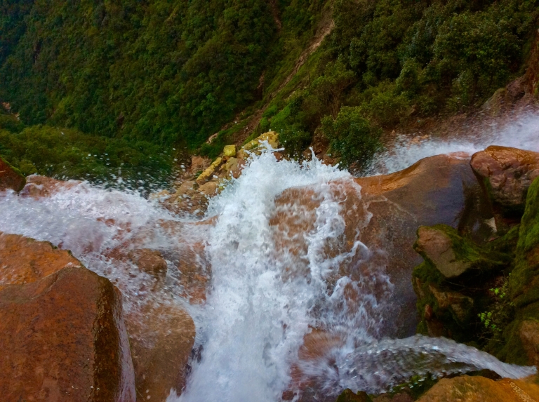
Just a few kilometres south of Sohra is Mawsmai village, famous for its cave and also waterfalls. We chose to visit the Thangkarang park first amongst others, thankfully it was not a Wednesday which is when the park remains closed. For a nominal entry fee of 10 INR, we entered the huge park which is a popular spot for locals looking to hold a picnic. The park is so huge that on one end we had some amazing views of the Kynrem falls and on the other we could see the plains of Bangladesh. Did you know that Kynrem is one of the highest waterfalls of India? But, it does not appear so as it not a single-drop fall, it is a stepped fall. As we stood glaring at the falls from a distance, our driver shared an experience he had with Kynrem falls; he pointed to the road beneath the falls and told us that one day it was right before his eyes that a truck was swept down into the valley because of the water from the falls. It was raining heavily and the wind was blowing strongly which caused the water to fall on the road sweeping off the truck. He vowed never to travel on that route during heavy rains. We felt a chill down our spines and realised that it was not because of the story, but because of the cool winds blowing from below.

We experienced rapid changes in the weather at least twice during our time at the park, foggy to sunny to rainy, the vagaries of weather kept us guessing. There is also a botanical park which houses a variety of flora found across the state. We spent quite some time in this enclosure watching a spider on a pitcher plant, hoping it would fall, but it did not. We headed on to Khoh Ramhah, or Maw Trop, as it is known locally. It is close enough to the park that on a clear day, it is visible from the park itself.

There is an interesting folktale behind the formation of this rock. The Khasis say that the rock is a huge upturned conical basket that belonged to a giant who terrorised this region through his acts. The people of the region who decided that he had to be dealt with, fed him a meal laden with sharp iron and nails. The giant ate it unknowingly and was killed, what remains of this incident is his basket which has been turned into a stone. The huge stone is watered by a seasonal waterfall right next to it, the name of which we are not sure of. There are telescopes here through which you can see the houses in Bangladesh and what a sight it was! After spying for some time on the residents of a Bangladeshi village, we left for our next destination. We stopped on the way at a betel nut farm. All along our way we noticed two plants that were grown in abundance: one was the betel nut plant and the other was the broomstick plant. They are sent from here to the rest of the country. We sat at the farm with our driver translating us the process of betel nut preparation right from the planting of the seed. It is amazing the amount of work that they have to do to produce these nuts that are a delicacy and also a type of addiction. They boil these nuts and then ferment them in water for many months before the nuts are finally ready to be cracked and sent. Here is a pic from the farm.

Our next destination was the Mawsmai cave, the most tourist-friendly cave in Meghalaya that is thronged by tourists, young and old alike as it is the only lighted cave in the state. Caving enthusiasts may find this too small a challenge, but let me assure you that this is not a cave that you can get breeze through. You will have to bend, squat, duck, roll and wade in water to get to the other end, but once you do it, you will realise how fun caving is. With the same enthusiasm, you may proceed to the other cave in this complex, that is not illuminated and requires you to put in a lot more effort to get through.

Even though the cave is illuminated, it is not a great place for photography and we will not be able to show you the formations inside, that is something for you to experience. Caving in Meghalaya is an activity that is fast gaining status among the international caving community especially because the caves here are highly under-explored. It is under constant threat from the illegal limestone industry as the cave systems here are of limestone. Efforts are being taken by the government to prevent the illegal mining mafia, but more awareness is needed to stop it completely.
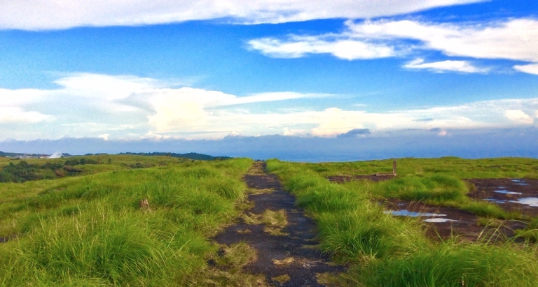
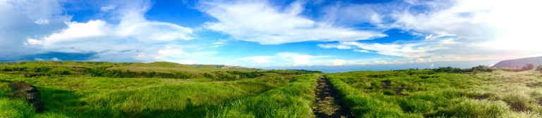
The highlight of our trip was the relaxing and beautiful Noh Kalikai falls. If we had to choose the single best event of our trip, it would be this. The calm, serene atmosphere having tis calm broken down only by the roar of the waterfall and the beautiful, flat grasslands with narrow winding roads running down them are a sight to behold. We recommend that you spend half a day here (if you have the time), no photo could do justice to this heaven on earth, it is merely an experience to be had. The water falls from a height of more than 300m spectacularly into a cerulean pool.

Noh Kalikai is made of two words: Noh meaning fall (not to be confused with falls) and Likai is the name of a woman who fell down from this place. Legend has it that a woman named Ka Likai was a member of the community that lived on the cliff above this falls. She had a daughter who was the apple of her eye, especially after her husband died. To have someone take care of her daughter, she decided to remarry. Her second husband, however, was a conceited, self-centered man who stayed at home and completely neglected their daughter. Neglect soon turned to jealousy and he killed the daughter when Likai was out working in the fields. He then cooked the daughter and served Likai the meat for her evening meal. Tragically, Likai relished the meal and had no clue about what it was until she found her daughter’s fingers in the betel nut basket. When she realised what she had done, she could no longer pardon herself and ran to the nearest cliff and threw herself down, joining the waterfall. And hence the name Noh Kalikai, meaning the fall of Likai.
If you want a closer look at the falls, there are two routes you could take, one is for a trek to the top of the falls and the other is to the pool at the bottom. If you went by the first route, you may probably encounter the settlements that people abandoned after the Likai incident. We opted for the second route and proceeded down the stairs near the parking lot. There is a huge swamp at the bottom and it has to be crossed to reach the pool. We turned back from here and reached the area behind the parking lot for a view point. We recovered from the mesmerising view of the waterfall only to be mesmerised by the view of the green grassland, it seemed to stretch endlessly and for good.
Another falls lay in store for us as we headed back to Shillong, this time though we were at the mouth of the waterfall. We had seen Wahkaba falls from a distance from Madan Shad Seng view point, but at the mouth of the waterfall is a totally different experience. One can view the Seven Sisters falls, Wahkaba falls and Latara falls from this view point. The Seven Sisters falls is also called Nohsngthiang falls as there are seven streams plunging down at the same location. There is an Eco Park which has been constructed atop the Nohsngthiang waterfalls which provides good views of the falls.

There is a small trek involved in reaching the mouth of Wahkaba, but is worth it. As we reached the actual mouth, we noticed that the flow of water was swift, but the water by itself was not deep. There were cement blocks that ensured that one did not slip when attempting to walk near the edges. The pool at the top is a good place to bathe or cool off, not that you will need to, when in Meghalaya. The legend behind this falls is that in ancient times, two fairies lived here. These fairies mingled in with the people and could be seen in Sohra amidst people as they looked exactly like humans. The only difference was that they had no shadows and anyone wary of this fact would stay away from them. They were fond of young men whom they mesmerised and kidnapped. Some returned after a span of two or three months claiming that they were married to a fairy, while some were not so lucky after all and never returned. And so goes the legend of Wahkaba.
While we have tried to cover all the possible spots in the Khasi hills, the list is simply exhaustive and as for Meghalaya with its seasonal falls and streams, you never know what you will be encountering until you are actually there and more often than not, you will end up spending more time at a place that was not even on the itinerary. We will be going back there, to complete our trip of Jaintia hills and a few left out spots such as Kyllang rock, Symper rock and Mawlyngbna among others. Until then, we have these beautiful memories with us.
References:
Most of our research material has been sourced from this site. This passionate site contains all about Mawphlang. Check out this documentary on caving in Meghalaya as well as this site. Do remember to check out this talented blogger whose blog we referred to before we planned our trip. For a detailed itinerary on Cherrapunji, use this. We may not have covered all the spots in the South West region.


Awesome photography of amazing unexplored north East!!
LikeLiked by 3 people
Thank you Alok sir for your time and comment. 🙂
LikeLiked by 2 people
Lovely
LikeLiked by 3 people
Thanks Vivek
LikeLiked by 2 people
What an interesting trip! I absolutely adore the photos and your thoughtful descriptions!
LikeLiked by 3 people
Thank you very much Daneen for stopping by.
LikeLiked by 2 people
I’ve never been to the area but I’m tempted after seeing your photos. Especially the heritage hills photo. Thanks for sharing.
LikeLiked by 3 people
Such an amazing post. The pictures are so beautiful. Shillong is a beautiful place. I have never been there but one of my friends showed me her travel video and I was convinced it’s one of the most beautiful places on earth. And we’re going there really soon. Thanks for the article.
LikeLiked by 3 people
These photos are great and the trip looks amazing! Definitely somewhere I would love to explore!
LikeLiked by 3 people
This post is so informative and interesting! Plus, your photography is breathtakingly gorgeous! Fantastic post!
LikeLiked by 3 people
Thank you Kristy. 🙂
LikeLiked by 2 people
Definitely, a new place to go on my bucket list, Thank you so much for sharing!
LikeLiked by 3 people
You will be in awe when you visit this place.
LikeLiked by 3 people
Your photos are amazing! They absolutely make this post worth it!!! Thanks for sharing your vast knowledge of the are, and the taxi advice!
LikeLiked by 3 people
Thank you, we are not really professional photographers though. The taxi bit will be very useful when one actually comes down here.
LikeLiked by 3 people
The post is extremely helpful to those who doesn’t know the gorgeousness of Meghalaya. The untouched beauty of khasi hills are perfectly explained. Hope more people know about the refreshness of valley of clouds.
LikeLiked by 3 people
Thanks Prabin for visiting the site. Yes, it is under-explored and needs to be publicised.
LikeLiked by 2 people
What an insightful post! I’m going to India in November and you’ve definitely convinced me to go and see the Khasi hills 🙂
LikeLiked by 3 people
Your comment just made our day. This is precisely what we aim for when we write our posts. 🙂
You can ask us for any help in this regard.
LikeLiked by 2 people
Very detailed and informative!
LikeLiked by 3 people
Wow what a trip…I really like the way you have documented it
LikeLiked by 3 people
Thank you. 🙂
LikeLiked by 2 people
So Amazing especially all the nature photos. I love the waterfall. I would love to go.
LikeLiked by 3 people
It is pretty, isn’t it?
LikeLiked by 2 people
Wow thanks a lot for all this helpful information! My husband used to travel to India a lot for business, and we’re planning to travel there together someday. I’ve saved your page for future holiday planning 😉
LikeLiked by 3 people
We have a couple of other under-explored Indian places on our blog, you may want to check them too.
LikeLiked by 2 people
Such an informative post! Thank you so much. Loved the photos too!
LikeLiked by 3 people
Thank you Rosanna for stopping by.
LikeLiked by 2 people
Hi, what a very detailed and informative post about a lesser known part of India. I would love to visit your photos captured your travels perfectly. I’m intrigued by the mushrooms.
LikeLiked by 3 people
I saw at least thirty types of mushrooms in the sacred forest.
And truth be told, we are but amateur photographers who are seriously considering buying a DSLR.
LikeLiked by 2 people
Stunning natural views and excellent captures! Very informative, too! Stumbled 🙂
LikeLiked by 3 people
Thank you. This should help you if you do ever plan to visit this place.
LikeLiked by 2 people
I am from India and never knew such a place existed beautiful
LikeLiked by 2 people
Honestly, I have tried to cover as many places as possible in one of the three regions of one of the seven sister states of the North-East. I leave the rest to your imagination.
LikeLiked by 1 person
Loved reading the post! Included pictures are great – keep it up!
LikeLiked by 2 people
Thank you very much for visiting. 🙂
LikeLiked by 2 people
I had no idea about this hidden gem of Hills. I am definitely going to travel here as I love traveling
LikeLiked by 2 people
Wonderful post!!!1The clouds coming down are a rare phenomenon observed in this particular region of the country which is amazing!!!
LikeLiked by 2 people
Yes, Megh Alaya indeed!!!
LikeLiked by 2 people
Great post! Very informative and wanderlusty 😉
LikeLiked by 2 people
Thank you for stopping by.
LikeLiked by 1 person
Looks like a really cool place – the stuff about the rituals is particularly interesting – and the Seven Sisters Falls looks incredible.
Enjoy the rest of your trip!
LikeLiked by 2 people
The rituals are incredible indeed. It is like the only thing that is constant is the landscape, constantly beautiful, the rest including the people and their customs change with every town.
LikeLiked by 2 people
Wow! Meghalaya is one unexplored beauty. thanks for sharing the information .
LikeLiked by 2 people
Thank you for stopping by, Aniket.
LikeLiked by 1 person
This was beautiful and captivating! As a book reader, I was a little sad I had to read it all in one go. You should consider breaking up the post and leaving us anticipating more!
India is definitely on my list and now I’m itching even more to go! Thanks for the hit of wanderlust!
LikeLiked by 2 people
Thank you Jes (which we are assuming is your name, sorry if it is not) for stopping by and for your helpful tip. And yeah, we were thinking once we do get to our own website, we would do a number of sub-posts. Our primary target audience is the book-reading travelling crowd, so we tend to keep the posts really long just so we can cover all the places of attraction in one go, so people who are planning the trip need not refer multiple sources. But, then, we do need viewership, so we will be breaking each post into multiple posts. Thank you once again.
LikeLiked by 2 people
Jes is correct and I look forward to your future posts!!
LikeLiked by 2 people
The Noh Kalikai falls picture was my favorite!!! Thank you for all the tips!! I have to put this down on my bucket list now! 🙂
LikeLiked by 2 people
It is a tough decision choosing between Noh Kalikai falls and the grasslands atop the cliff. You will know when you visit. 😀
LikeLiked by 1 person
North East India is the only part of India that I have not covered. After reading this I would surely be visiting soon 🙂
LikeLiked by 2 people
Just to put things into perspective, we have covered around one-third of one state of the seven states there. If you get the time, do cover each state individually.
LikeLiked by 1 person
I love reading about new places that I only travel to via my internet connection! Your pics are awesome. Honestly, there was so much interesting information and details I wanted to know more about that I would have kept coming back if this long post was broken into several smaller ones – there’s just a lot of interesting components that stand alone on their own.
LikeLiked by 2 people
Thanks for stopping by. And, we are currently working on breaking our posts into smaller posts. Do keep visiting our blog regularly for updates.
LikeLiked by 1 person
Awesome photography and beautiful place well done 👍👍
LikeLiked by 2 people
Thank you Tanyisha, hope it would help you if you ever decide to visit this place.
LikeLiked by 1 person
Wow! Such informative adventures and they way you have documented!
LikeLiked by 2 people
Thank you Stuti. 🙂
LikeLiked by 1 person
Can you tell me why travel from June to September is risky?
It seems like such a beautiful place. Your pictures are amazing.
LikeLiked by 2 people
Risky only because of flash floods that may occur. Also, nearby places including airport at Guwahati are usually closed at this time. September usually becomes OK to travel. We went in August and could not visit certain areas because they were just recovering from floods.
LikeLiked by 1 person
This was long but worth the read.
LikeLiked by 2 people
Thank you for your patience. 🙂
LikeLiked by 2 people
Beautiful place, lovely write up
LikeLiked by 2 people
Thank you Anumita. 🙂
LikeLiked by 1 person
It looks like an amazing place!!! I love how wild nature is combined with civilization.
Thank you so much for sharing! Reading it, made me feel that I am already there!!!
LikeLiked by 2 people
Fantastic post- looks like an amazing place. Your pictures make me feel like i’m almost there!
LikeLiked by 2 people
|barefootveronicaluna|
very informative & lovely pictures! Looks like a beautiful place. Thanks for sharing 🙂
LikeLiked by 2 people
This is a really comprehensive post. Thanks for taking the time to write this guide x
LikeLiked by 2 people
Thank you for taking the time to visit our blog. 🙂
LikeLiked by 1 person
I am in awe of your trip. What a beautiful place to see. So green and pretty!
LikeLiked by 2 people
It sounds amazing! I’d love to visit here one day. Oh, and I’m also fluent in miming during foreign travel. 🙂
LikeLiked by 2 people
Your pics are awesome. Honestly, there was so much interesting information and details I wanted to know more about that I would have kept coming back if this
LikeLiked by 1 person
Thank you for sharing travel exprience. shillong heart of north east. really awsome picture along with great writeup.
land of culture, music, fashion, waterfalls, tribes and many more
LikeLiked by 1 person
Thank you. But it would be better if you check out unboundoutbound.com because we have moved our blog from here and you’ll be able to find more stories there. 🙂
LikeLiked by 1 person
ok Thank you
check out some of my blog post hope you like it
https://indiantravelservices.wordpress.com/
LikeLike